

Knutsford Catenians (and friends) – climbing to the Stratosphere for East Cheshire Hospice

How high is the Stratosphere?

It starts at about 10km (6 miles) and finishes at 50km (31 miles).

Our goal

To ascend a minimum of 10km, 10,000m. 33,000 feet (but ideally 20km, 20,000m. 65,000 feet) by repeated climbs of Alderley Edge from Nether Alderley. Each metre of ascent from everyone who takes part will count towards the total.

This is the same as:

  • Climbing Everest 1.2 (2.3) times
  • Climbing Mt. Blanc 2.1 (4.2) times
  • Climbing Ben Nevis eight (fifteen) times
  • Climbing  3,333 (6,667) stairs (as measured on your watch by Garmin or Apple)

How?

By cycling or walking up to Alderley Edge many times.

A cycling round trip is about 115m of ascent, a walking round trip is about 80m of ascent.  So 10km requires between 85 and 125 ascents.  This is not a trivial challenge.

Why?

To raise money for the East Cheshire Hospice – Knutsford Catenians Charity for 2025/26.  We would like to raise £2,000.

We are raising money through justgiving – please encourage donations at https://www.justgiving.com/page/stratosphere

Get Involved

If you would like to participate in the event please let us know at events@knutsford.p17catenians.org or contact either Nick Johnson or Stuart Jones.

Let us know if you want to:

  • Cycle
  • Walk
  • Be a supporter (encourage participants, give out water and snacks)

When?

  • Tuesday 23rd September
  • First people start at 09:00
  • Finish at 17:00 (if anyone is still left going then)
  • You can join at any time

If you cannot make the 23rd September it is OK to contribute your ascent on the weekends before or after. If you do this it would be helpful to share your achievement with a screenshot of whatever tracking tool you use.

Some Practical Details

Cycling

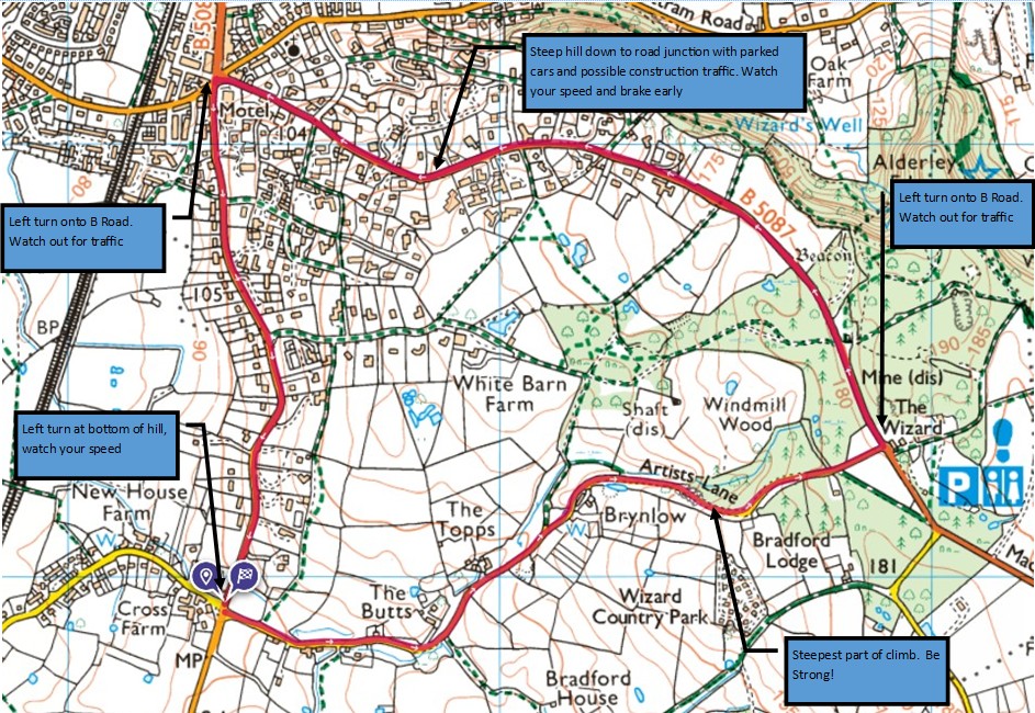
Cycling will be on a circular route.  We start at  the bottom of Artist’s Lane, cycle up to the junction  opposite the  Wizard Pub (now closed), then down the hill to Alderley Edge where we turn left along the road back to Artist’s lane.  This is  a 5km circuit with 115m of ascent.
Walking

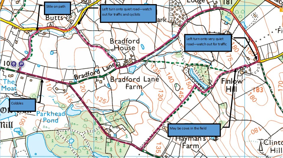
To avoid walking on the road the walk will start  at nether Alderley School and follow a circular route up Hocker Lane and Finlow Hill before heading down Bradford Lane and Artists Lane.  It is 4.4km long with an ascent of 83m from the school or 72m from the junction of Bradford and Hocker Lane
Measuring Total Ascent

If you have a bike computer, or a smart watch that can measure ascent, we will ask you to record your walk/ride and share the details with us.

Otherwise we will count the number of times you do the ascent.

We will then add everything up

Support

Café: The Wizard Café at Alderley Edge Car Park will be open for those craving proper coffee.

Toilets: At Alderley Edge Car Park

Parking:  There is some free car parking at Nether Alderley Mill.  Car parking is also available at St. Mary’s Church , Nether Alderley (donation requested).  At the top you can park at Alderley Edge (free for National Trust members).

Support:  Will be provided (drinks and snacks (at the bottom of Artists Lane).

Want to know more

Please contact Stuart Jones (secretary@knutsford.p17catenians.org)

Risk Assessment

Name of activity, event, and location: Stratosphere Ride and Walking Event, Artists Lane, Alderley Edge

Date of Activity: 23rd September 2025

Date of risk assessment: 23rd August 2025

Date of next review: 15th September 2025

Name of person doing this risk assessment: Stuart Jones

What could go wrong?
What hazard have you identified? What are the risks from it?
Who is at risk?What are you going to do about it?
How are the risks already controlled?
What extra controls are needed?
How will they be communicated to young people and adults and remain inclusive to all needs?
Review & revise
What has changed that needs to be thought about and controlled?
Drop off and Pick Up Risk of collision from vehiclesEveryoneBoth venues have car parks suitable for a safe drop off and pick up Participants to assemble and wait safely away in Lay By (Cyclists), outside the school (Walkers)NA
Traffic and Moving VehiclesAdult walkersRoute planned in advance and route check walk undertaken with no high traffic areas
Route is mainly off road, where road walking is required normal measures taken and participants to be extra vigilant  
NA
Traffic and Moving VehiclesAdult cyclistsRoute planned in advance and route check cycle undertaken the main climb is low traffic with higher levels of traffic down the hill to Alderley Edge. 
All turns are left turns Riders asked to follow the normal rules of the road, be aware of traffic and parked cars on the descent to Alderley Edge, wear visible clothing or use lights and to ensure that bikes are in good roadworthy condition
NA
General risk of slips, trips, or falls, and injuries caused by collisionsAdult walkersMake sure that particpants are wearing appropriate footwearRoute planned in advance and route check walk undertaken and general hazards identified on hazard map
Appropriate first aid kit carried by lead First aid if required.
      NA
General risk of slips, trips, or falls, and injuries caused by collisionsAdult cyclistsMake sure that particpants are wearing appropriate clothing including a bike helmet.
Route planned in advance and route check walk undertaken and general hazards identified on hazard map
Appropriate first aid kit carried by lead
NA
Risk of extreme weather (heavy rain, lightning, thunder, snow/hail)Adult walkers & cyclistsIf forecast is bad before the event, event will be postponed.
Participants to wear appropriate clothing, and all participants to have waterproofs if raining or if rain is forecast.
If bad weather is persistent on the day the event will be cancelled 
In the event of lightning participants will be advised to stay away from metal objects (pylons / fence lines etc) as well as avoid sheltering under trees.
NA
Risk of sting injuries from nettles and insects  Adult walkers & CyclistsRoute planned in advance and route check walk undertaken and general hazards identified on hazard map
First aid if required.
     
Lost group memberAdult walkers & cyclistsRegister and Headcount to be taken at start of activityRoute map shared with participants prior to leaving start location.  Headcount taken regularly by lead/support team. 
Participants to carry mobile phones and numbers shared.
Participants asked to text leader when they have finished for the day  E
mergency services to be contacted promptly in case of missing persons.
     
Other unforeseen hazardsEveryoneRoute planned in advance and route check walk undertaken and general hazards identified on hazard map
Dynamic risk assessment to be performed by all during walk/cycle
Hazards to be shared with other participants and appropriate mitigation to be actioned.